As 2025 Hurricane Season Begins, Stevens Prepares Communities in the Region
University’s experts share life-saving data, forecast and warning tools
Last year’s hurricane season was an active one.
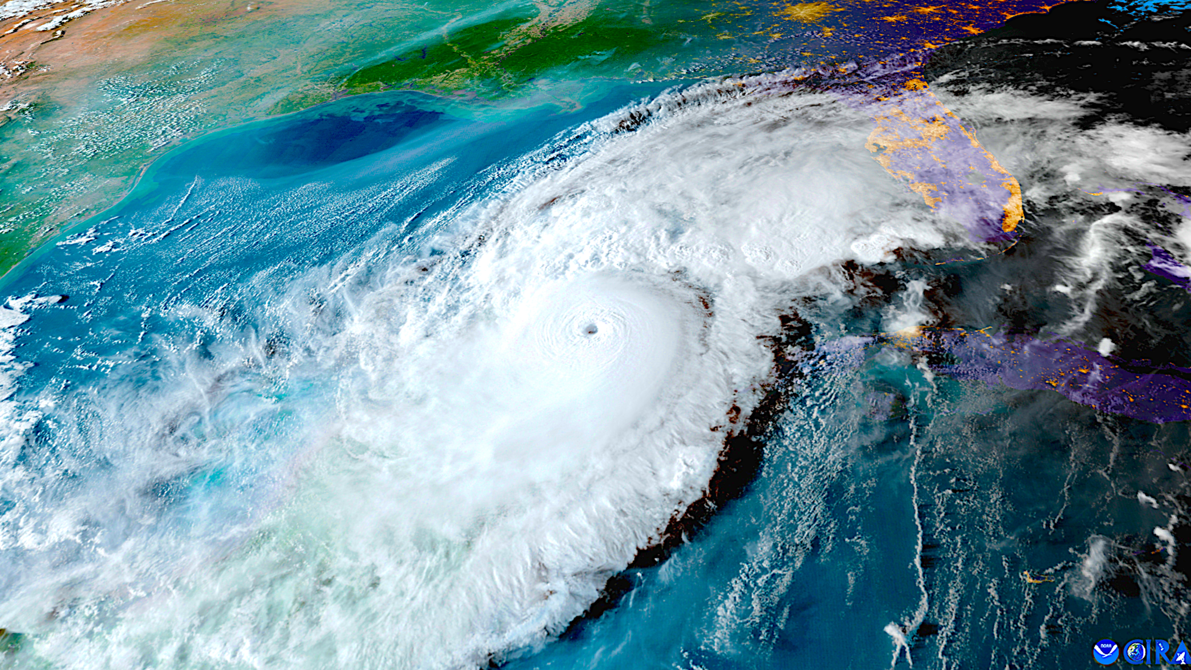
Eighteen tropical storms developed in the Atlantic basin during the official five-month season, including 11 hurricanes. Two of those, Helene in September and Milton in October, were particularly dangerous: Helene was the deadliest U.S. hurricane since 2005, killing 250 people, while both rank among the costliest-damage hurricanes in U.S. history.
Now forecasters are predicting another busy season for 2025.
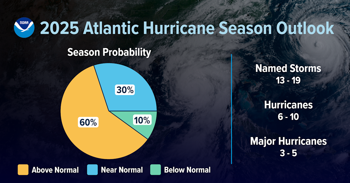 NOAA, the National Oceanic and Atmospheric Administration, released its official forecast in late May, predicting a 60% chance of a more active-than-usual summer and early fall. NOAA expects the Atlantic region to see 13 to 19 named storms this year, six to 10 hurricanes packing winds of at least 74 miles per hour or more — and three to five Category 3 or stronger storms, which would bring winds of at least 111 miles per hour.
As always, Stevens’ resiliency experts will be on call to provide data, modeling, warning and forecasts and to publicly discuss the challenges of storm surges, flood tides, heavy rains and other extreme-weather threats.
How Stevens informs emergency planning
Stevens research has previously demonstrated that communication peaks just before or during a hurricane's strike, and that extreme events disrupt community cohesion. So it's important to be prepared.
Experts in the university's Davidson Laboratory continually model and forecast extreme weather events, supplying relevant agencies and communities with data and helping warn the public of flood and surge events associated with hurricanes or large storms as many as four days in advance.
Stevens supplies the National Weather Service, for instance, with data that informs its storm forecasts. Local planners and regional agencies also tap Stevens’ expertise.
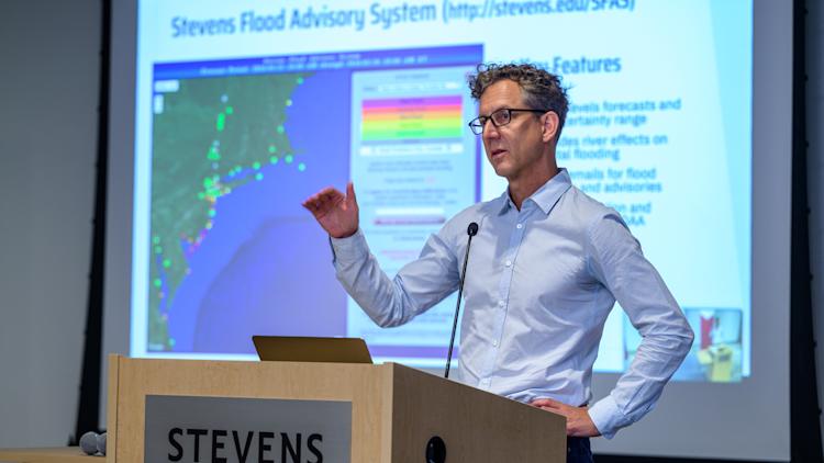
“Most days, the first piece of information I check in the morning,” notes Caleb Stratton, chief resilience officer for the city of Hoboken, about the Stevens Flood Advisory System — a free online monitoring and forecasting tool maintained by the university.
In recognition of this expertise, the U.S. government and state of New Jersey each in the past year re-committed funding support to the university’s extreme-event prediction, planning and public information tools. Coming enhancements include improved forecasting, additional supercomputing resources, autonomous sea and air vehicles with LiDAR capabilities, portable weather stations, a sophisticated X-band weather radar system and other hardware and software tools.
Coastal hurricanes: Worst-case scenarios
Coastal hurricanes in urban areas are particularly dangerous, bringing together a devastating combined effect of wind, waves, flooding, storm surges and overwhelmed drainage systems on urban coastal communities.
 Davidson Lab researcher Philip Orton has provided research demonstrating how for mid-latitude areas such as New Jersey and New York, hurricanes are primarily responsible for extreme events — though assessments often underweight them due to their small numbers, leading to underestimation of what is called "tail risk."
“In the past 15 years we have seen record-setting extremes of both surge and rain, leading to flooded streets, homes, high-traffic expressways and boulevards, subways,” he explains. “Our region's infrastructure was not engineered to factor in either the sea rising or rain intensifying and will require adaptation.”
 Reza Marsooli, another Davidson Lab researcher, models flooding, storm surges and wave hazards during periods of changing climate. With approximately 95 million Americans — nearly one-third of the U.S. population — residing in coastal regions, his work supplies the nation's cities and communities with key intelligence as planners work to build both physical defenses and emergency response plans.
Marsooli has published findings concluding New York's Jamaica Bay will soon begin flooding much more frequently. His research has also assessed the potential impacts of future hurricanes on coastal erosion hazards along the New Jersey Atlantic coast.
“The computational framework we used for these studies can also be replicated," he notes, "to demonstrate how coastal erosion and flooding in other regions will look by the end of the century, which will help mitigate risk and better protect communities.”
Media outlets frequently turn to Stevens during extreme-weather events. NPR, PBS and Yahoo! all recently quoted university experts on natural disasters including storms, floods and wildfires.
Below, Orton and Marsooli answer some common questions about hurricane-season threats to the northeastern U.S., extreme rainfall — and some of the tools being developed and upgraded to help prepare communities and inform response.
Extreme Weather FAQs with Stevens experts
Q: Is the weather becoming more extreme?
A: Yes. A host of recent studies worldwide have confirmed that summers are indeed becoming hotter and rainier; storms are becoming stronger; and floods are becoming more frequent and stronger as a result of sea level rise and changes in storms.
Q: Why is this happening?
A: The Earth’s base temperature has warmed by almost two degrees Fahrenheit during the past century alone. That doesn’t sound like much, but it has already been enough to melt and unlock huge quantities of glacial ice in Greenland, Antarctica and other locations.
All this extra meltwater empties directly into the world’s oceans, where it slowly rises against continents and islands. This sea-level rise, driven by a warming and expanding ocean, is one of the primary challenges created by global warming.
The warming atmosphere and ocean also produce increased tropical-region heat and humidity, which help birth and strengthen destructive storm systems such as hurricanes.
Stevens research published in the leading scientific journal Nature Communications has demonstrated how the effects of major regional hurricanes like Hurricane Sandy are significantly worsened by the human-driven effects of this climatic change. In the case of Sandy, this additional damage is estimated to have been perhaps $8 billion.
Q: How will this affect those living near coastlines?
A: If you live in a low-lying coastal area that occasionally flooded during storms in the past, prepare for much more frequent floods. Coastal erosion is also expected to worsen in many regions due to sea level rise and the increasing intensity of storms.
 Coastal areas along the entire Eastern Seaboard of the United States — from Florida to New England — will experience higher coastal flooding during storms in the foreseeable future. One study led by Marsooli confirms that hurricane-induced flooding will continue to become more severe along both the U.S. Atlantic and Gulf coasts over time, due to global warming.
Q: Why are hurricanes so dangerous for the metro NYC region?
A: Flood risk studies, insurance products and flood maps typically assume rain and coastal storm surge are independent processes. Recent Stevens analyses of New York City historical data have shown that rain and storm surge generally have low correlations.
However, during tropical cyclones, this research shows that when one factor becomes extreme, the probability of the other factor also becoming high elevates. Tropical cyclones cause more extreme hazards compared with other storm types, and they’re responsible for a majority of the most extreme events (even though they occur far less frequently), including the most extreme rain-surge events.
It’s very important, as a next step, that we better understand New York City’s compound rain-surge flooding by simulating extreme-event scenarios in flood models. Why? Because that compound flooding may be likely to occur more and more frequently in the near future, to higher and higher levels.
Q: How else is Stevens helping prepare New Jersey, New York and the nation for future hurricanes, storms and flood events?
A: Physical defenses and warning systems are regularly discussed, planned, developed and tested by Davidson Laboratory faculty, students and researchers.
The Stevens Flood Advisory System (SFAS), a free real-time resource accessible to the public, produces four-day advance flood forecasts for the New Jersey and Metro New York coastal region. Not only does SFAS provide a central forecast, it also shows the uncertainty in a given forecast, helping convey potential high-end (worst-case) consequences.
Led by professor Jon Miller, Stevens also operates the New Jersey Coastal Protection Technical Assistance Service, supporting efforts to cope with beach loss during strong storms, and authors an annual State of the Shore report on beach health for the New Jersey Sea Grant Consortium. The university develops research on innovative approaches and technologies to protecting the coast such as so-called “living shorelines” of natural materials including oyster reefs and coastal plantings.