How Stevens Produces World-Class Flood Forecasting for NYC and Beyond
Stevens Institute of Technology's advanced flood-warning system just became better than ever — helping save lives & property in New York, New Jersey and beyond
During October of 2012, as Hurricane Sandy bore down on the Northeastern U.S., Stevens Institute of Technology professor and Davidson Laboratory director Alan Blumberg took to the airwaves to make urgent appeals based on flood-forecast data Stevens laboratories were churning out just ahead of the powerful storm.
Speaking live with Weather Channel meteorologist Jim Cantore, as Cantore stood beside rising harbor waters in New York City's Battery Park, Blumberg calmly informed Cantore the sea would be six feet higher (at least) on the spot where he stood within hours.
Pointing up at a nearby lamppost for viewers, Cantore was incredulous.

But Blumberg was right. Sandy produced the highest floods and storm surges ever recorded in the city, and nearly $70 billion in damage along the Eastern Seaboard. Many communities were not ready.
“Frankly, as a nation and as a region, we were unprepared,” said U.S. Senator Charles Schumer of New York later.
Fast-forward to last fall, as Hurricane Hermine approached. State and federal officials raised alarms; Blumberg, however, advised reporters the storm was "a lot of hype." It would take more than 24 hours for the National Hurricane Center to agree and lift warnings.
Then, this spring as winter storm Stella pivoted and drew a bull's-eye on the Northeast, planners and emergency responders scrambled once more to understand the uncertain potential for snow and flooding, declaring states of emergency. But Stevens' models showed no flood threat, and Blumberg privately counseled officials against overreacting.
Right again.
In a relatively short time, Stevens has developed a national reputation for forecasting storm and flood conditions with startling accuracy, helping local and federal officials plan for the worst cases while also cautioning against overreaction.
"[Stevens provides] a valuable resource for automated warning emails and for quantitative predictions of water levels," wrote Dan Zarrilli, chief resilience officer for New York City Mayor Bill de Blasio in a recent letter acknowledging the university's contributions to city emergency planning and decision-making.
"We can do a good job predicting about 96 hours out into the future, and now we are quantifying the uncertainty of those predictions," explains Blumberg. "Our Stevens models and real-time observations have become integrated and we are getting very, very experienced at this forecasting business. We are now so trusted that federal and local agencies look to us for guidance."
Accurate models, supercomputing power
The story of the Stevens flood-forecast model begins at Princeton University, where Blumberg — a postdoctoral researcher at Princeton — began a long collaboration with professor George Mellor, world-renowned for his studies of geophysical turbulence. Building on Blumberg's Ph.D. research, they developed a new advanced numerical model that could handle complex coastal ocean processes.
The physics of that model, known as the Princeton Ocean Model, begin with traditional three-dimensional hydrodynamic equations for conservation of mass, momentum, temperature and salinity. But by making and justifying important simplifications, the duo created a fresh set of equations that were still accurate, yet became easier and quicker to solve.
As his interest in shallow waters lying adjacent to urban areas grew, Blumberg eventually collaborated with Stevens research professor Nickitas Georgas to build a successor model, the Stevens Estuarine and Coastal Ocean Model (sECOM).
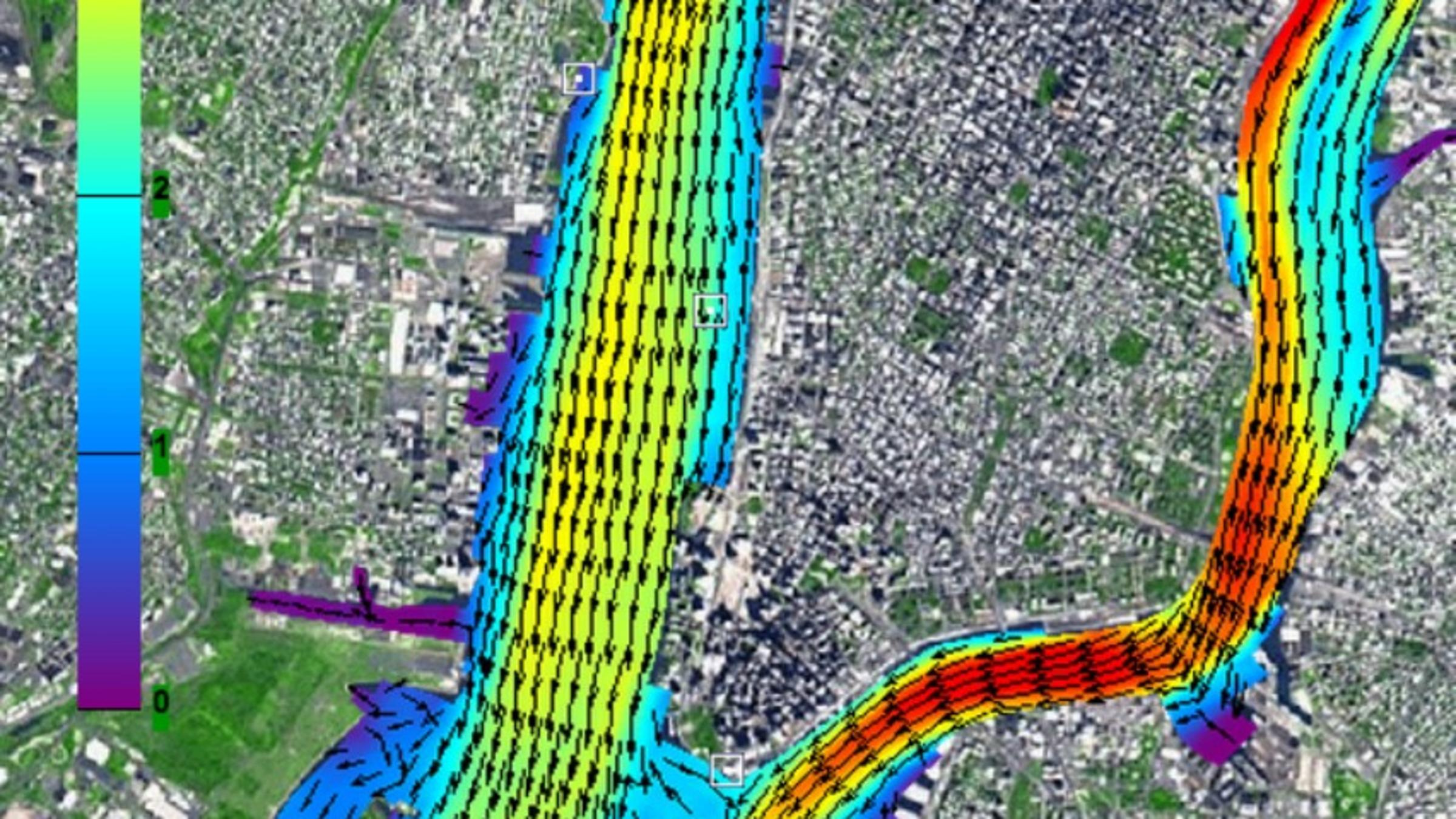
The sECOM is now considered the model of choice for scientists and engineers worldwide seeking to model urban-ocean environments — and it forms the backbone of both Stevens' New York Harbor Observing and Prediction System (NYHOPS) and its Stevens Flood Advisory Service (SFAS), two highly trusted forecast and visualization tools.
This newer model integrates surface weather data, wave dynamics, water temperature and changes in salinity as data streams in from a variety of sources, including dozens of monitor buoys scattered throughout the waters of New York, New Jersey and Connecticut. This aggregated data is combined to produce highly accurate forecasts of local winds, river flows, incoming tidal surges and flood potential in the metropolitan New York region, including for Manhattan and Hoboken on a street-by-street basis.
"The university's forecasting is considered accurate enough that the National Weather Service now sends website viewers interested in New York City-area flood predictions directly to these Stevens tools," notes Blumberg, adding that the National Oceanic and Atmospheric Administration's (NOAA) National Ocean Service posts Stevens' forecasts to its website as well.
In the fall of 2014, the Port Authority of New York/New Jersey (PANYNJ) awarded Stevens $6.6 million to improve both the forecasts and public flood-warning systems. That award included funds to purchase a new supercomputer to help perform the forecasts more efficiently and to distribute additional sensors in New York Harbor.
Several months after the PANYNJ award, New Jersey Transit followed suit by awarding an additional contract to the university to develop similar forecasts and public warnings for transportation infrastructure in the Garden State. And Blumberg has also provided forecasting and advice to the past two mayors of New York City as part of a key planning panel as the city loads up for a massive planning and flood-infrastructure initiative.
New computing techniques further improve accuracy
More recently, Blumberg, Georgas and Research Professor Antoni Jordi worked to further speed and improve the forecast's calculations by introducing parallel computing, a method by which portions of rapid computations are divided up and made separately and simultaneously. (Vertical components of the Stevens forecast calculations are not divided, since rivers and oceans are far wider than they are deep.)
The calculations are also decomposed, or simplified into fewer data cells on the grid representing the bodies of water, to speed processing.
This new methodology, recently published in the journal Ocean Dynamics, creates even more detailed models of storm surge than were previously available. The system can now supply flood and surge guidance up to four days in advance, with 90 percent accuracy, providing planners with ample time to warn the public, evacuate as needed, move critical infrastructure and otherwise prepare for extreme-weather events.
Stevens researcher Firas Saleh, an expert on riverine flood models, has also contributed additional expertise as the forecasts are fine-tuned. (Saleh's model of the Philadelphia area, complete with an animated simulation, shows Eastcik-area streets completely submerged by an Irene- or Sandy-sized event.
"This is why we do this work," concludes Blumberg. "We want to ensure safety and resilience in the face of both extreme events and gradual sea level rise, not only in New York City but in New Jersey and similar coastal urban environments worldwide."