This App Will Help Hoboken Residents Stay Dry During a Flood

Crowd-sourced data in a fast, beautiful interface keeps the community on top of the weather
Staying dry is not easy in Hoboken. The city floods frequently, as it’s located on the Hudson River’s floodplain and is only three feet above sea level at its lowest point.
Thankfully, a team of senior design students at Stevens Institute of Technology is trying to solve that problem with an app—and they’re unveiling it at Stevens Annual Innovation Expo.
This isn’t the first time Stevens has tried to help Hoboken. Other projects include an award-winning stormwater containment plan, a parking finder app, and a 3D popup map of Hoboken. But this app, created by computer science students Divy Tolla, Jeff Mariconda, Henry Thomas, Nishanth Meni and Karan Shah, and business school students Erica Guketlov, Daphne Ginn, Allison McDougall, Kelly Klewicki, Shannon Norkus and Julia Loria, has potential for bigger impact. “Being able to work on something that can potentially benefit the city,” was why Klewicki was drawn to the project. So was the rest of the team.
With that goal in mind, they got to work.
The result is the Environet app. The team partnered with community helpline Hoboken 311 “which people love,” Klewicki said. Hoboken 311 already had a built-in user base and social media aspect, making it an ideal resource for the team. “We didn’t get any bad reception [when we pitched it],” Guketlov said. “Everyone thought this would be useful… So many people [already] use an app that’s so similar for reporting things like broken streetlights or potholes. It’s much better to have one for flooding. And it’s easy to put into an app.”
In order to get that data, the team had app users sign up for an Environet account via Facebook or Twitter. After creating that login, a user enters data into the app, selecting street corners where they see flooding and entering roughly how many inches of water they see. Once they do, the app immediately generates a line showing the street as flooded. Every other user on the app sees that line. The darker it is, the worse the flooding.
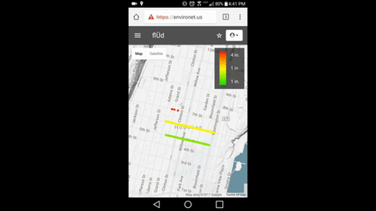
The data is not only local: it's location-specific, meaning if your phone’s location is set as Hoboken “you shouldn’t be able to input data for NYC,” Meni said.
Users also can’t just enter single street corners; they need to enter at least two for tracking purposes. “We’re not doing puddles,” Meni said, “It’s doesn’t make sense to enter just one point.”
Advisor Alan Blumberg, director of the Davidson Laboratory, is thrilled by the team’s progress. “These students are geniuses,” he said. “I came to them with the idea and they made it happen.”
Right now, the team is fine tuning the app for the expo. First, they’d like to move their data storage to a private server to speed up its data recall, despite its lightning fast performance on mobile. “It’s [still] a little slower than we’d like,” Meni explained, referring to the web browser functionality.

The team is continuing user testing to improve the experience, including finding solutions for colorblind users. They’re testing how frequently they should refresh the app’s data for maximum efficacy. They’re even going for a patent. “Patent pending sounds a little more official,” Klewicki explained, shedding light on the team’s plan to take the product to market. They’re getting a little help with that plan from global advertising firm Grey Advertising, who was so impressed by the demo they offered their services pro bono.
Ultimately, the team would like to add even more to the app, possibly including traffic, wind conditions, even temperature because “no one tells you where there’s black ice or where people are hydroplaning,” Guketlov explained. They'd also like to roll it out to as many cities as possible.

Expect to see the fully functional app by the Expo, along with a poster. That doesn’t mean it’ll be completely finished, of course: they want to make the app even better. “We want to keep building and building,” Klewicki said.
Given that Hoboken is on its way to becoming a smart city, it looks like they’ll have the opportunity to keep building. And the students couldn’t be happier.
“It’s cool to use what we’re learning here to help the city of Hoboken,” Guketlov said. “I think this can really have an impact.”
“We’re doing something bigger than ourselves,” Klewicki agreed. “We’re bringing the community together, and giving people the opportunity to bring the community together themselves. We want to be able to help out as much as we can.”
See for yourself at the Innovation Expo on May 3.